Author Archives: admin

2015: Year of Action

IMG-20140623-00202The Elk Complex Wildfire of August 2013 will have long-lasting effects on the lower South Fork Boise River.

One short and medium term effect is the focus on recovery after the wildfire. After a year of emergency rehabilitation efforts, including an initial planting effort November 9, 2013, and an August 2014 manipulation of flows to attempt to move sediment, attention now turns to longer-term work on recovering the vegetation along the river corridor.

In mid-September 2014 the Forest Service finalized its decision for the South Fork Boise River Corridor Post-Fire Restoration Project. Implementation was planned to begin in the fall of 2014.  Some other things took priority over the recovery project, such as getting a larger culvert on Granite Creek.  Plus, it took time for the plants to grow.

TIME FOR A PROJECT

At a minimum, there will be two opportunities to help out this spring. The first event will be on February 28th:

  • Volunteers will cut willow cuttings from designated areas along the river.
  • These cuttings will be brought to Lucky Peak Nursery and held for us in coolers until a planting day, later in the spring.
  • The cutting event is scheduled for next Saturday, the last day in February!
  • If you are interested in joining in, please contact Pam Harrington at 345-9800, preferably by Wednesday at latest. Depending how large of a crew we have, we might need to ask folks to bring pruners/loppers.

Don’t worry if you will not make February 28th.  There will be additional planting dates, likely late March and mid April.

“At this time we have 3,414 seedlings available to plant this spring,” says Scott Bodle, a wildlife biologist with the Boise National Forest. “About 2/3 are cottonwoods and 1/3 willow. Based on the turn out we had last time your groups came together I believe we could plant the entire amount in a day using volunteers.”

In addition to the seedlings Bodle mentions there will also be the cuttings collected February 28th.

Stay in touch.  This is the year we begin some of the recovery work!


The Late August Flow Surge

The Bureau of Reclamation announced in an August 13 news release that flows on the South Fork Boise River will rise to 2,400 cfs for several days to transport sediment in the river and help improve fish habitat.

This action comes after several months planning a response to the August 2013 wildfire which burned much of the SFB watershed, followed by heavy rains September 12, 2013 that caused several debris flows that delivered sediment and debris into the South Fork Boise River.  Additional storms this summer have added more material and debris to several locations along the South Fork.
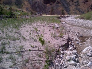
Granite Creek blowout upstream of the South Fork Boise River Road.

Granite Creek blowout upstream of the South Fork Boise River Road.

A South Fork Boise Recovery Team; including US Forest Service, Trout Unlimited, University of Idaho, Idaho Department of Fish and Game, and U.S. Bureau of Reclamation met and developed flow recommendations and a rationale.  Here are some highlights of their information:

Fire and the resulting sediment and debris slides are a natural and regular occurrence in southern Idaho and the Idaho Batholith. In natural systems, fires impact fish populations positively and negatively. In managed systems, impacts may be more or less severe depending on circumstances.

Changes in sediment regimes may be one of the largest changes to stream networks post fire. A tremendous amount of fine sediment was added to the SFBR during these events. Fine sediments affected the quality and quantity of overwintering habitat by filling in side channels and interstitial spaces along the shoreline, these habitat features are critical for the survival of bull trout, rainbow trout, and their prey bases. Reduced quality and quantity of overwintering habitat and spawning habitat for prey fishes affect bull trout. Fisheries surveys in the fall of 2013 and spring of 2014 show reduced numbers of age-0 rainbow trout that will support the future rainbow trout fishery and serve as prey fish for bull trout. In a natural system, these sediment inputs are sorted and transported under naturally occurring high flows during spring snowmelt. In regulated systems, such as the SFBR, high flow events are attenuated to mitigate flood risk and to store water for irrigation (and other uses). The regulated flows result in lower peak flows especially in poor water years or years with low carryover storage like the winter of 2013/2014. During these conditions, less fine sediment is transported leading to longer-term detrimental impacts to bull trout, their habitats, and other aquatic biota.

The multi-agency group held meetings November14, 2013, March 5, May 29, and July 18, 2014.  In addition to developing a list of data needs to assess potential responses to mitigate the effects of the fires and resulting debris flows, and discussing results from sediment modeling and recent fish surveys, the team recommended flow shaping to:

  1. Provide as much stability as possible during the rainbow trout spawning period;
  2. Provide stability for incubating rainbow trout eggs; and
  3. Increase reservoir storage, in anticipation that increased storage would enable a flushing pulse that could be used to mobilize fine sediment during the 2014 spring runoff period.

Storage in the Boise River system precluded a flushing event in the late spring as there was little room to store the flushed water in the lower system (Arrowrock and Luck Peak reservoirs). Thus the team “believes that a pulsing flow is an important step to hasten recovery of important fish populations and habitats found within the SFBR. As such, the team reconvened after learning that a spring flush was not possible to update the sediment model and discuss options for a flushing pulse later during the 2014 water year.”
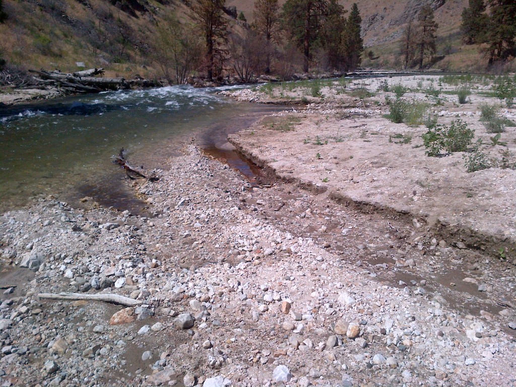
South Fork Boise River flows cut a channel through the sediment.

Summer 2014 – South Fork Boise River flows cut a channel through the sediment.

The University of Idaho’s Ecohydraulics group developed a 1 dimensional (1D) coupled hydraulic and sediment transport model of the river from  Anderson Ranch Dam Gage to Neal Bridge to simulate sediment transport through the system.

The volume of recently deposited sediment (debris fan) was estimated by field measurements.  Five debris fans were identified within 10 miles downstream of Anderson Ranch Dam. The 1D sediment model predicts that size of sediment that will move under certain flow volumes given the channel cross-sectional shape and slope. Sediment particles less than the size used by spawning fishes were considered in the model.

Existing LiDAR DEM data was used to extract cross-sectional depth data to more accurately identify just how deep some of the recently deposited sediment fans are, and to identify where redistribution of sediment would occur.  Three
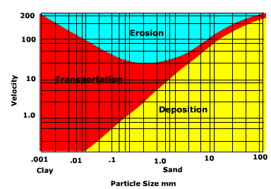
Movement of sediment depends on speed of water and size of sediment particles.

Movement of sediment depends on speed of water and size of sediment particles.

different discharge magnitude and duration scenarios (recommended by the team) were used to investigate total volume of sediment transport from debris fans, upper canyon and canyon sections. Discharge scenarios included a pulse of 2000 cfs for 8 days; 2400 cfs for 8 days; and 3000 cfs for three months.

Sediment transport simulations based on the 1D model showed that the 2014 irrigation flows of 1600 cfs move some sediment but do not erode the debris fans completely. Part of the mobilized sediment is deposited in lower velocity reaches like pools and the remaining sediment remains in transport.

Key findings from latest modeling:

  • A flow pulse of 2000 cfs for 8 days does not visibly change the sediment transport.
  • A flow pulse of 2400 cfs or greater for 8 days causes a detectable change in the deposition of sediment while improving the quality of both overwintering and spawning habitat.
  • Flows in excess of 3000 cfs, sustained for as long as three months will mobilize fine sediments but will not flush them out of the river corridor into Arrowrock Reservoir.

Analysis of potential depositional areas shows that overwintering habitat and spawning reaches should not experience large deposits of fine sediments, improving the quality of both habitat types.

We recommend a flow pulse of at least 2400cfs for a minimum of eight days based on the new results from U of I’s sediment transport model.

The Bureau of Reclamation is required to protect critical habitat for bull trout habitat, thus the water storage levels in both Anderson Ranch and Arrowrock reservoirs require attention during the same time period as the recommended pulsing flows. Neither requirement will be jeopardized as a result of the recommended flow pulse. Furthermore, water used for the flushing pulse (approximately 8,000 acre feet), if stored in Arrowrock Reservoir through November 2014, would provide an additional benefit to migratory bull trout returning to Arrowrock Reservoir.

The flow increase is scheduled to begin Monday the 18th.


Tagged

Never This Low This Late

Discharge from Anderson Ranch Dam remains at 300 cfs as we enter Memorial Day weekend.  If you are wondering if this has ever happened before, at least in the modern era, the answer is no.  Since the operations manual for the Boise River was adopted by the Bureau of Reclamation in the early 1980s the flows have increased to 600 cfs in early April in most of the years.  The operations manual sets out a plan for the South Fork Boise to have 600 cfs around April 1 of each year to help water up some side channels and to provide more habitat for main stem spawning rainbow trout.

There were a couple of years where the April 1 plan was not met, such as in 1993 and 2002 when Anderson Ranch reservoir was approximately 25 percent full.  The flows in those years did not increase until May.  In 1987 and 1988 the flow increase was delayed for a couple of weeks.  And now 2014 stands out as the latest year on record where we will probably come close to June before the river flows increase.

image001

Approximate date each year when flows increased above the 300 cfs winter time minimum flow operation. Most years the flow would increase to 600 cfs in one day. Other years the increase was more protracted.

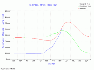
In 1997 there was so much water in the reservoir and snow piling up in the back country mountains that the river went from 300 cfs to 600 cfs the day after Christmas 1996.  At the other extreme it was 1992 when Anderson Ranch reservoir was down to 45,000 acre feet, yet the flows did increase to 600 cfs anyway.  Years 1993 and 2002 represent situations where the reservoir was on the empty side of things 115,000 and 145,000 acre feet respectively.  And April 2014 the reservoir was in the same neighborhood, around 140,000 acre feet.  One reason given for holding the river at 300 cfs is to

and_af_wy05242014make repairs to the outlet and let the water go over the spillway for a few days.  The hearsay in fishing and water circles is the operation is avoiding sending too much water to Arrowrock and Lucky Peak so flood control operations are averted.  The effect of holding the flows at 300 cfs appears to be meeting an objective of keeping as much water in the most upstream storage location as possible.  Since the first of April the water behind Anderson Ranch has doubled from 150,000 acre feet to approximately 300,000 acre feet.  Full Pool is 413,000 acre feet so things have a ways to go.  But in the last week the amount of water in the pool has surpassed that of last year and the blue line is converging on the red line of the long-term average.  Holding the river at 300 cfs until Anderson Ranch reservoir is full may also create an opportunity for releasing a high flow or pulse of water through the South Fork to help move sediment that is in the river from last September’s debris flows.  If an operation like that gets serious consideration we will provide more information on this website.

Boat Raffle, Fly Casting Competition to aid South Fork

If you want to help recovery of the South Fork of the Boise River and also take a chance to win a boat, you should get involved in this raffle.

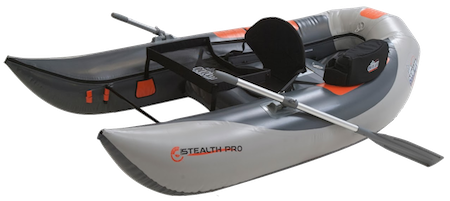
Thanks to a generous donation by Outcast Sporting Gear we are raffling the OSG Stealth Pro, a pontoon boat that is both light weight (35 lbs) and durable.

http://emailimages.tumembership.org/chapter_images/0000/0687/stealthpro_pontoon450.png

Raffle tickets are on sale for this boat.  Tickets are $25.00 each. We limited the number sold to just 100 tickets.  Tickets are on sale at Anglers Orvis fly shop on Overland Road and at Idaho Angler on Vista, or use the magic of online credit card transactions and you can purchase it here!

The boat will be raffled on Saturday May 10 at lunch at the 4th annual fly casting tournament at Eagle Island State Park.

The cause remains the same:  conservation of the South Fork Boise River wild trout fishery.

Last year the Third Annual Fly Casting Tournament raised approximately $7,000 toward projects to improve the South Fork of the Boise River fishery.  Located just an hour away from Boise, the South Fork still provides that experience we all seek in Idaho: to get away and to have great fishing — for our families and ourselves.

In the spring of 2012 we completed the replacement of a culvert with a bridge to reconnect Pierce Creek to the South Fork of the Boise River and provide access to 1.9 miles of healthy habitat for trout spawning and rearing.  We also launched an unprecedented cooperative project with the Bureau of Reclamation and the Idaho Department of Fish and Game to study the effects of river flow changes on the young wild trout of the South Fork. This study will continue in 2014 and 2015 and could eventually lead to adjustments in flow management.

With river corridor damages resulting from devastating wildfires in the summer of 2013, plus post fire tributary blowouts caused by heavy rainfall, we anticipate the need for a variety of projects to help heal the river and its blue ribbon trout fishery.

With our recent and past successes – and continued work – on the South Fork Boise River, we would like you to consider joining other individuals and businesses in support of our 4th Annual Fly Casting Tournament, being held on Saturday, May 10, 2014 at Eagle Island State Park. Organize a casting team and sign up here!

Forest seeks, gets comments on South Fork Rehab

SFBrehabmap

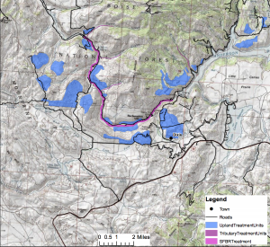
Map of recovery project area. Click on it to enlarge.

The Boise National Forest’s Mountain Home Ranger District asked for public comment on a scoping document on proposed post-wildfire recovery of the South Fork Boise River area.  Within a 50,000 acre analysis area the Forest proposes to plant some 7,000 acres of upland areas and 1,500 acres of riparian areas.

Comments were accepted from February 7 to March 7, 2014.  The Forest received comments from the Boise Valley Fly Fishers (.pdf) and from the Ted Trueblood Chapter of Trout Unlimited (.pdf) among others.  The Forest will complete the recovery plan in 2014 with the goal of significant planting efforts beginning in 2015.  Comments from Trout Unlimited pointed out that in 2014 it would be possible to collect seed from cottonwood trees in the summer, and begin to grow new trees from locally-sourced seeds.  TU and the Boise National Forest’s Lucky Peak Nursery pioneered this practice since 2011.  And in the fall 2014 it should be possible to put willow cuttings along riparian areas where needed, assuming appropriate sources of willow can be found.

If you are interested in following this recovery project you can provide your email to the Boise National Forest here.